Critical Incident Mapping
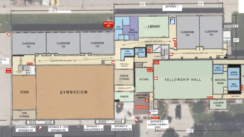
Critical incident mapping provides a digital blueprint that can be easily accessed by law enforcement on cell phones or other devices during a crisis. This tool is instrumental in expediting response times, aiding first responders in swiftly identifying and isolating threats, and facilitating the most efficient evacuation procedures.
TechRender’s critical incident mapping solution equips law enforcement, EMS services, and private security teams with detailed information for effective emergency response. Our rapid and accurate 3D scanning process generates precise maps and comprehensive documentation, empowering first responders to swiftly and efficiently navigate complex environments. TechRender’s maps empower EMS services to respond to emergencies with the utmost preparedness, ensuring optimal response times and effective decision-making.
- Rapid and Accurate Mapping
- Proactive Safety Solution
- Maps Provided Directly to EMS Services

Why Critical Incident Mapping is Needed
Every second counts in emergencies, yet miscommunication about unfamiliar locations can cripple response efforts. Critical Response Mapping bridges this gap, providing a shared visual language for first responders, security personnel, and building administrators. With clear, pre-prepared maps of buildings and grounds, everyone speaks the same language, saving precious moments and potentially even lives during critical incidents.

Now, with TechRender’s help, you can secure your facility, worry-free. TechRender is at the forefront of digital mapping and taking the first step in securing your building.
APPLICATIONS
FACTS. ANSWERS. QUESTIONS.
TechRender is there to guide you through the mapping process and get you answers for your Critical Incident Mapping Project.
FEDERAL AND LOCAL GRANTS
Securing funding for critical incident mapping can feel like navigating a maze, but TechRender is your expert guide. We’ll demystify the grant landscape, identifying local and federal opportunities. Partnering with us means streamlined applications, compelling narratives, and unwavering support throughout the process – leaving you free to focus on what matters most: keeping your community safe.
EMS SERVICES
TechRender doesn’t just map buildings, we map your community’s needs. We collaborate closely with EMS services to ensure critical incident maps meet specific regional protocols and address unique challenges. From incorporating specialized equipment layouts to prioritizing access points for different response teams, our maps become customized tools that empower EMS to navigate situations with precision and confidence, tailored to your community’s unique heartbeat.
PRIVACY
TechRender prioritizes privacy and understands sensitive building data deserves careful custodianship. We adhere to the strictest security protocols, ensuring mapping data is only shared with authorized personnel. Your blueprints and maps are solely accessible to designated school officials, building administrators, and local EMS responders. Rest assured, your critical information rests in secure hands, ready to empower a swift and effective response when every second counts.


